Castle-Hunting with a 400-Year-Old Map: What Baxter c.1600 Tells Us About Lost Ó Dubhda Strongholds
April 20, 2026 2026-05-07 1:15Castle-Hunting with a 400-Year-Old Map: What Baxter c.1600 Tells Us About Lost Ó Dubhda Strongholds
Castle-Hunting with a 400-Year-Old Map: What Baxter c.1600 Tells Us About Lost Ó Dubhda Strongholds
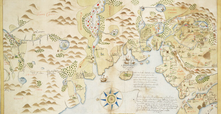
At Parke’s Castle in County Leitrim, framed on the wall of the visitor centre, hangs a reproduction of a map almost none of the passing tourists look at carefully. It is hand-drawn in ink and watercolour, labelled in a cramped Elizabethan secretary hand, and speckled with tiny castle towers. It shows the northwest of Ireland around the year 1600 — the Moy estuary, the Ox Mountains, Sligo Bay, Donegal, and a generous helping of O’Rourke and Burke territory. And written in red ink, diagonally across the area that stretches from the River Moy to the heart of Tireragh, is a phrase that stops us in our tracks.
“O Dowdes Countrie.”
We knew the map existed. We had not looked at it up close. When we did, we found that it holds clues that may lead us to castles this clan has not yet rediscovered.
The map itself
The map’s full title is A true description of the Norwest partes of Irelande. It was drawn around 1600 by an English sea-captain called John Baxter, compiled from direct observation on the ground, and finished in Antwerp by the Italian mapmaker Baptista Boazio. It was an intelligence document — made for an English commander who needed to know, in the middle of the Nine Years War, where every harbour, castle, bog, and friendly-or-unfriendly fortification stood along the coast.
The original now sits in the Dartmouth Collection at the Royal Museums Greenwich, catalogued as P/49(7). On display it would measure about the size of a small tablecloth. It is the earliest surviving map that writes “O Dowdes Countrie” onto the Sligo coast as a territory name — and it does not stop there. It draws our castles.
We have now catalogued it in the Maps page, with a link to the Royal Museums Greenwich record.
What we can still read, four hundred years later
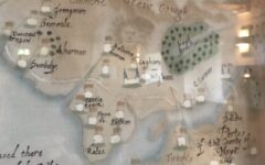
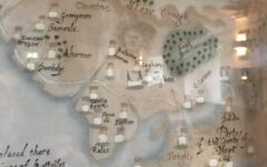
We spent a day with a high-resolution scan of the sheet and a magnifier. Here is a partial transcript of the castle names Baxter inked onto the Tireragh coast and the Moy estuary, reading roughly north-to-south along the shore:
- Avanaglas — Ardnaglass
- Serone — Scurmore
- Grangemore — Grangemore
- Castle Towne — Castletown / Cottlestown
- Roslee — Rosslee
- Kilglasse — Kilglass
- Belleke (on the Mayo side of the Moy) — Belleek Castle, Ballina
- Rosse or Rosserck — Rosserk Abbey
- Killala — clearly drawn with a church symbol
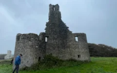
All of these we already have pages for. All of these were either Ó Dubhda fortifications or abbeys that sat within Ó Dubhda territory. It is profoundly moving to see them drawn, one after the other, by an Elizabethan cartographer who was almost certainly on the ground with an Ó Dubhda chief still living in the tower when he sketched them.
And then come the names we cannot place.
Castles we did not know about
Drawn with the same little tower symbol, in the same ink, and labelled in the same hand, are a series of names that do not appear on Conor Mac Hale’s canonical 1617 list of twenty Ó Dubhda castles. Some of them may be variant spellings of sites we already know. Others are a genuine mystery.
- Grangbeg — “little Grange” — drawn immediately north of Grangemore. Possibly an ecclesiastical satellite, possibly a small secondary tower, now ploughed out.
- Dunbuoy — Dún Buí, “the yellow fort” — a coastal tower south of Aughris. Not on any list we hold.
- Duncarragh — Dún Cárrach, “the rough fort” — drawn inland between Aughris and Grangemore. No modern townland answers to the name.
- Akarnan — a small inland tower. Unidentified.
- Larrac — on the coast west of Duncarragh. Unidentified.
- Sunchien — unidentified.
- Dunlum — drawn near Ardnaglass. May be a Baxter-era reading of a name already on our list, or may be separate.
- Flynas — near Castletown. A likely alternate rendering of Doonflin (Dún Flinn), on Mac Hale’s 1617 list but not yet documented with its own page.
- Lishen — near Flynas. Unidentified.
- Balle baxter — drawn in the Sligo interior near Lough Gill. The name reads, almost comically, as “Baxter’s Town.” If this is the cartographer’s personal garrison point, marked on his own map, it is a quiet historical joke worth investigating in the State Papers.
Some of these will shake out, as the research proceeds, as variants of names we already track. Others may prove to be sites that fell out of use long before the first Ordnance Survey and were never mapped since. Either way, the Baxter map may contain keys to a whole network of forgotten Ó Dubhda towers, preserved in red ink and Spanish-Armada-era English spelling for four centuries.
Three of the strongest candidates — Grangbeg, Dunbuoy, and Duncarragh — have now been added to our Lost Castles ledger as working stubs. Each will be worked on until it is either confirmed on the ground or ruled out as a duplicate.
An echo of the inauguration mound?
One detail of the Baxter map is, frankly, eerie. In the very centre of “O Dowdes Countrie,” Baxter’s draughtsman drew a large radiant sun symbol, positioned on the landward side in the foothills of the Ox Mountains. It sits roughly where, on a modern map, you would find Carn Amhalghaidh — the Ó Dubhda inauguration mound, the place where every chief of the clan was made king from the early medieval period up to the 1585 Composition of Connacht. It is not proof — the sun also functioned as a decorative cartouche — but Elizabethan maps of Ireland did sometimes mark ceremonial sites with special symbols, and if Baxter’s sun is the cairn, it is the earliest known map to show the inauguration site as a landmark in its own right. The cairn was almost completely levelled in the early twentieth century; Baxter may have seen it still standing.
How to hunt a lost castle
People ask us how this work is actually done. It is not glamorous. It is not Time Team. But it is deeply satisfying, and anyone with patience and a good pair of boots can contribute. The method is roughly:
1. Start with the written record
Mac Hale (1990) is the anchor. Tony Dowd’s family archives extend it. John O’Donovan’s 1836 Ordnance Survey Letters for County Sligo and County Mayo sometimes name sites that had already half-vanished a century ago. The Annals name castles at the moments they were burned or stormed. Each of these is a candidate to follow up.
2. Triangulate with the old maps
Speed 1610, Boazio 1606, the Down Survey barony sheets of the 1650s, Taylor & Skinner’s 1778 road atlas, Beaufort 1797, and now Baxter c.1600. A castle that appears on three independent maps is unlikely to be a scribal ghost. A castle that appears on only one is worth extra scrutiny — but Baxter’s towers, drawn from direct observation rather than copied from an earlier sheet, deserve to be taken seriously.
3. Resolve the name
Read the Irish-language form under the English spelling. “Dunbuoy” is Dún Buí. “Avanaglas” is Ard na gCleas — Ardnaglass. “Grangbeg” is An Ghráinseach Bheag. Irish toponymy is remarkably stable across centuries: the townland that once held a castle usually still carries the name of the fort in one form or another, long after the stones themselves have gone.
4. Cross-reference to the modern landscape
The online resources at logainm.ie (the Placenames Database of Ireland) and dúchas.ie (the Schools Folklore Collection) are free, excellent, and searchable. So are the historic OS 6-inch and 25-inch maps on GeoHive. Many “lost” castles turn out to be on modern maps already — just under a name nobody has connected back to the clan.
5. Walk the ground
Most of what remains of the Ó Dubhda castle ring survives not as standing walls but as earthworks — low mounds, cropmarks, disturbed ground, a suspicious old wall in a field corner. A good afternoon’s walk with a local farmer who knows the fields beats any archive search we have ever tried. Often the farmer will tell you, quite casually, that “there used to be an old castle there, sure.” He is almost always right.
6. Bring in the specialists when you have something
LiDAR, geophysics, and formal archaeological survey cost money — but the National Monuments Service is endlessly generous with its time when a credible new candidate is presented. We are currently exploring a full professional archaeological survey of the whole Ó Dubhda castle network. If you can contribute to that — financially, with your time, or with your knowledge — please get in touch.
7. Keep a public ledger
This is the purpose of the Lost Castles page on this website. Every candidate is listed. Every time a new one comes to light, it joins the working list. Every time a site graduates off the list into the main Castle Tour, we count it as a win for the clan.
Why this matters
It would be easy to treat a stack of old manuscript maps as an academic curiosity. It is easy to look at Mac Hale’s list of twenty castles and think the count is closed. Neither is true. The Baxter map alone, carefully read, may add three to five new entries to the ledger. And Baxter is only one of more than a dozen early maps of the northwest. The Down Survey, the Civil Survey, the Books of Survey and Distribution, the estate maps of the Jones, the Gore-Booths and the Cromwellian planters — every one of them contains drawings, names and boundary lines that someone, eventually, needs to sit down and cross-reference against the clan’s memory of itself.
That work is not finished. Every map we read tells us something Mac Hale did not know. Every farmer we talk to tells us something the maps do not. Somewhere in the hinterland of Aughris, on a slight rise in a cow field, there is a stone that used to be the wall of Dún Cárrach.
We would like to find it.
Sources and further reading
- Captain John Baxter and Baptista Boazio, A true description of the Norwest partes of Irelande, manuscript map, c. 1600. Royal Museums Greenwich, Dartmouth Collection, P/49(7). Catalogued in our Maps page.
- Patrick Mac Hale, The Ó Dubhda Family History (1990) — the twenty-castle list and its additions.
- John O’Donovan, Ordnance Survey Letters — County Sligo / County Mayo (1836).
- The Down Survey of Ireland, 1656–58 — digitised at downsurvey.tcd.ie.
- Logainm.ie and dúchas.ie — indispensable, both free.
- The Ó Dubhda Lost Castles ledger — the working list that this research feeds into.