Tanrego Castle
May 2, 2026 2026-05-07 1:53Tanrego Castle
TANREGO CASTLE
Tanrego Castle
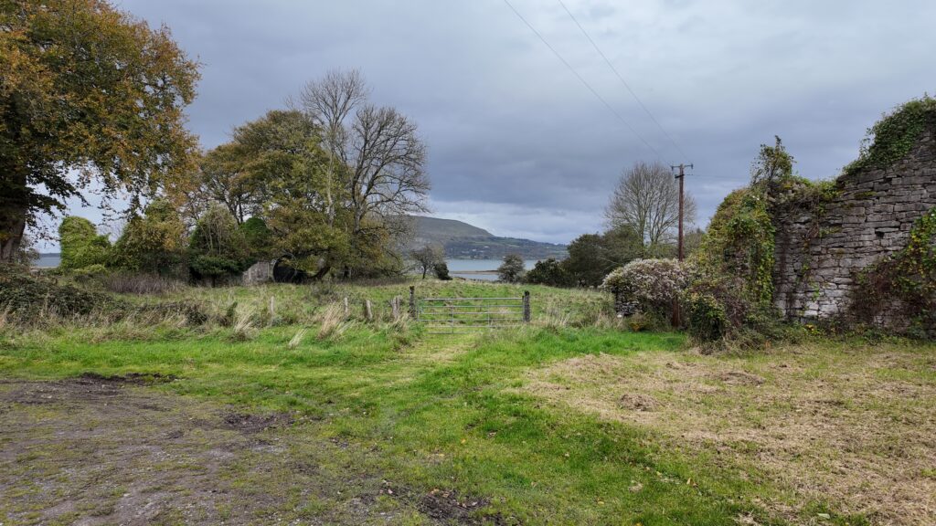
A fortified bawn on the southern shore of Ballysadare Bay
Tanrego Castle stands in the townland of Tanrego West, in the civil parish of Dromard and the barony of Tireragh, Co. Sligo, close to the southern shore of Ballysadare Bay. It is not a tower house in the commonly understood sense, but a ruined fortified courtyard — a bawn — built in two distinct phases in the late sixteenth and early seventeenth centuries and protected today under the National Monuments Acts (RMP SL019-062).
I. Setting and Antiquity
The present-day townland of Tanrego West takes its name from the older form Tóin re Gó — rendered in the Ordnance Survey letters of 1836 as “hill projecting toward the sea.” The name is coarsely expressive rather than ornamental and recalls the low promontory on which the castle sits. Tanrego East is, for practical purposes, an alternative name for the adjacent townland of Carrowmore, and in medieval sources the two names are sometimes used interchangeably for the same landholding.
The coast at Tanrego has been settled since the Neolithic: a shell midden on the foreshore close to the castle has been radiocarbon-dated to c.3660–3440 BC. By the time the bawn was raised, the site had already been a place of habitation for more than four millennia.
II. A Place Within the Ó Dubhda Lordship
Tanrego lies at the eastern extremity of the barony of Tireragh, which in the medieval period formed the core of the Ó Dubhda lordship of Uí Fhiachrach. Before the Anglo-Norman intrusion, that lordship reached westwards across the River Moy into north Mayo, taking in the later baronies of Erris, Tirawley and Carra.
From the mid-thirteenth century until 1371, Tireragh was held by the de Bermingham family, who had displaced the Ó Dubhdas during the Anglo-Norman advance into Connacht. In 1371 the territory was recovered by Domhnall Cléireach Ó Dubhda, and Tireragh remained within the clan’s sphere until the Elizabethan re-orderings of the late sixteenth century.
The wider Tireragh context is essential for reading Tanrego: the same landscape contains the Ó Dubhda seat at Ardnaglass, the coastal rock of Roslee at Easkey, and the early-fifteenth-century house at Liafuine (Leaffony) near Kilglass, where Maolruanaidh son of Ruaidhri Ó Dubhda died in 1447 — a reminder, recorded by the Ó Dubhda chronicler Dubhaltach Mac Fhirbhisigh, that Tanrego was one dwelling-place among several in the same barony-wide patchwork of the clan.
III. Tanrego in the Fiants — A Gaelic Quarter, c.1584–1635
References to Tanrego in the medieval record are scarce, but the Elizabethan fiants place several individuals there in the 1580s and 1590s. In 1584 Tanrego was re-granted to Donal O’Connor Sligo, alongside extensive lands in Tireragh, Carbury, Leyney, Tirerril and Corren, under the policy of “surrender and regrant.” Browne’s map of Sligo of 1589 already shows a castle at the site, labelled Tourego.
Between 1592 and 1593, pardons issued at Dublin Castle named at least four Gaelic householders of Tonregoe: Edmund O Bocline (1592), Tiege Boy Ó Dubhda and Marcus O Nary (1593), and Brian McCarre (1593). Taken together, the pardons suggest that by the turn of the seventeenth century Tanrego supported a small cluster of Gaelic families, including at least one branch of the Ó Dubhdas themselves.
The Strafford Survey of the mid-1630s lists Tanrego among four quarters — Carrowmore (Tonrego), Carrowbeg, Carrowmoriston and Carrowgarry — held at that date by the MacSweeneys and mortgaged to a “Mr Dodwell” for £8 each per annum. The surveyor observed bluntly: “It is all good arable lande; there is a good castle uppon Carrowmore, save the one rowme. Every quarter will graze 30 cowes, and is worth £8 10s per ann.”
IV. The Fortified Bawn: Architecture and Phases
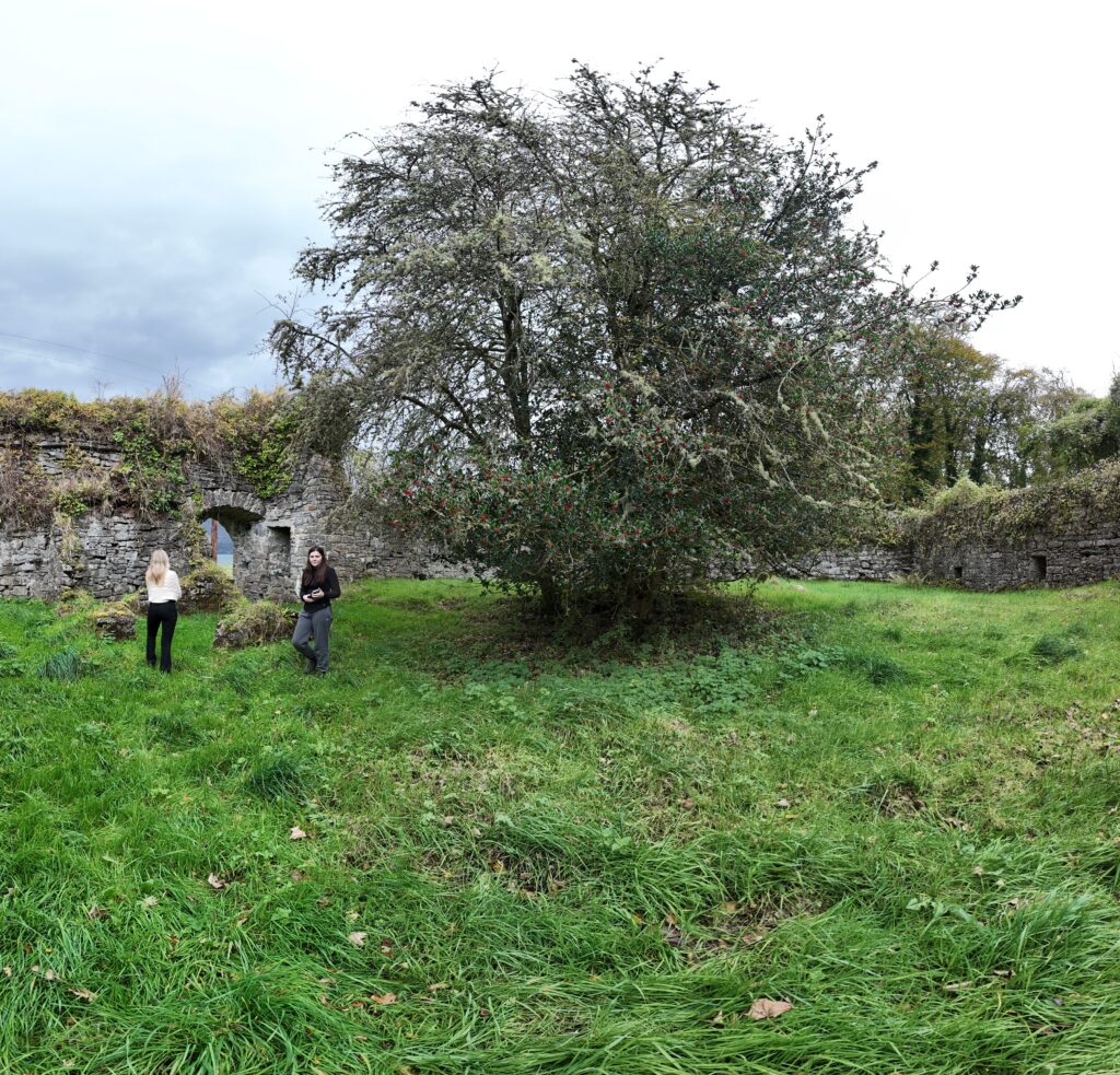
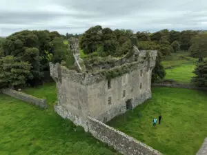
The surviving remains at Tanrego were surveyed in detail in 2016 by Dr Rory Sherlock and Dr Paul Naessens, in an appraisal commissioned by the landowners. Their work showed that the castle is a sub-rectangular bawn measuring some 28.5 m east-to-west by 22 m north-to-south, built in two distinct phases.
The earlier, eastern first-phase bawn measured about 16.4 m by 14.2 m internally, enclosed by a wall roughly 0.80 m thick. Its eastern wall met the southern wall at an angle of 95°, giving the enclosure an irregular quadrilateral plan. Its defining features were two circular gun turrets at the north-east and south-west corners, each fitted with a single row of gun-loops and finished with unusual corbelled roofs that give them the outward appearance of capstans. The southern and eastern walls are punctuated by numerous gun-loops, many of them later blocked.
The later, second-phase bawn extends the enclosure westwards by roughly 10 m and measures about 22 m north-to-south. Its walls are taller — standing up to 5.3 m high — and thicker, between 1.0 m and 1.2 m. It has fewer gun-loops than the first phase, but they are larger: a well-preserved example in the west wall has a 40 cm wide horizontal mouth. The original entrance, a pointed-arched gateway at the eastern end of the north wall, retains a wicker-centred rear arch — the impression in the mortar of the basketwork used as temporary centring during construction, a technique common to late medieval and seventeenth-century Irish masonry. Inside the gateway, a recess holds a small gun-loop positioned above a waste chute.
A ruined rectangular house, about 11.65 m by 6 m, lies immediately to the north of the bawn. It may date from the seventeenth century, and Sherlock and Naessens note that it is likely to have been the principal residence in Tanrego West in the post-medieval period.
V. Post-Medieval Descent — Dodwells, Crichtons, Irwins
George Dodwell of Tanrego is listed in the Hearth Money Rolls of Sligo for 1665, paying tax on three hearths — a mark of a substantial residence. In 1670 the castle, town and lands of Tonregoe were granted, under the Patent Rolls of Charles II, to John Vaughan; but the Dodwells were still seated at Tanrego a century later, when their name appears against the site on Taylor and Skinner’s Maps of the Roads of Ireland (1777).
The Dodwells had been transplanted into Connacht under the Cromwellian settlement and held Carrowgarry, Tanrego and adjoining lands into the nineteenth century. On the death in 1832 of Edward Dodwell — the topographer and antiquary whose Classical and Topographical Tour through Greece (1819) earned him wider note — much of the estate passed to his sister Frances and her husband, Sir Alexander Crichton, court physician to Tsar Alexander I of Russia. Frances and Alexander had been married in 1800. The Crichtons let the townland of Tanrego West to Colonel John Irwin of Tanrego House, a commissioner of the Sligo Gaol in 1813, and the Ordnance Survey Name Books record “an old castle” standing close to Col. Irwin’s residence.
Through the eighteenth and nineteenth centuries the bawn appears to have been put to use as a farmyard: several small buildings were inserted against its inner walls, further blocking gun-loops and blurring the military character of the site.
VI. Current State
Tanrego Castle today is a ruin on working farmland. The bawn walls stand to a maximum height of about 5.3 m on the west side. Both round corner turrets, with their distinctive corbelled roofs, survive. The northern gateway with its wicker-centred arch is intact and remains the principal point of entry. Many gun-loops are blocked or damaged, but the overall plan of both phases can still be read clearly from the masonry. The site is on private land and in private ownership; any visit requires prior permission from the landowner.
As Sherlock and Naessens concluded in 2016, it remains an open question whether the bawn ever enclosed a tower house, or whether it was always the “whole castle” referred to in the historical record. Only targeted archaeological excavation would answer that. Meanwhile, Tanrego is a rare and unusually legible example of a small, two-phase Irish bawn — a fortification raised at the edge of Gaelic Ireland on the cusp of its transformation.
Sources and Further Reading
- Sherlock, R. & Naessens, P. (2016), Tanrego Castle, County Sligo — Archaeological Appraisal. Unpublished report commissioned by David and Mary Willis, Carrowgarry House, Beltra, Co. Sligo.
- Browne’s Map of Sligo, 1589 (showing “Tourego” castle).
- Down Survey, c.1657 — parish of Dromard and barony of Tireragh maps (Trinity College Dublin, downsurvey.tcd.ie).
- Taylor & Skinner, Maps of the Roads of Ireland, 1777.
- Nicholls, K. W. (ed.), The Irish Fiants of the Tudor Sovereigns (De Burca, 1994).
- Wood-Martin, W. G., History of Sligo, County and Town (Hodges, Figgis & Co., 1889).
- McTernan, J. C., Sligo: The Light of Bygone Days, vols. 1 & 2 (Avena, 2009).
- Mac Fhirbhisigh, D., Leabhar na nGenealach (ed. N. Ó Muraíle, 2003–2004).
- FitzPatrick, E. & Fenwick, J. (2001), ‘The Gathering Place of Tír Fhiachrach?’, Proc. Royal Irish Academy, 101C, 67–105.
- Ordnance Survey Name Books — Co. Sligo (c.1836).
- Archaeological Survey of Ireland, record SL019-062: archaeology.ie.
Tanrego Castle
Caisleán Thóin re Gó
Tanrego West, parish of Dromard,
barony of Tireragh, Co. Sligo
ITM 560054, 831410
Fortified bawn, built in two distinct phases. Corner gun turrets with corbelled roofs and a wicker-centred arched gateway. No surviving tower house; it remains unresolved whether one ever stood within.
Late sixteenth to early seventeenth century. Already shown on Browne's Map of Sligo, 1589.
Ruined. Bawn walls stand to c.5.3 m on the west; both corner turrets survive; the arched gateway is intact. Later farm buildings were inserted against the inner walls. Record of Monuments and Places SL019-062.
In private ownership. Access by prior permission of the landowner only.
Tanrego lay within the Ó Dubhda lordship of Uí Fhiachrach until the Anglo-Norman intrusion of the mid-1200s. Tireragh was recovered for the clan in 1371 by Domhnall Cléireach Ó Dubhda. By 1593, Tiege Boy Ó Dubhda was among the Gaelic householders of Tonregoe named in the Elizabethan fiants.
Protected under the National Monuments Acts 1930–2014. Dated principally from the archaeological appraisal of Dr Rory Sherlock and Dr Paul Naessens (October 2016).
From the Clan
Photographs of Tanrego Castle submitted by clan members.
Latest stories tied to Tanrego Castle.
Tales, research and dispatches from the Ó Dubhda journal.
How Many Castles Did the O’Dowds Actually Have? (More Than You Think — and We’re Still Counting)
The popular ’20 castles’ figure keeps growing as new field reports, old maps, and survey records turn up Ó Dubhda sites no one had counted. Here’s where the tally stands.
A Note from the Clan
These castle pages are written and maintained by volunteers of the Ó Dubhda (O’Dowd) Clan, drawing on primary sources — Elizabethan fiants, the Ordnance Survey Name Books, Mac Fhirbhisigh’s Leabhar na nGenealach, and modern archaeological survey — to keep the record as honest as our evidence allows.
If you spot an error, or know a local tradition, photograph or document that we have missed, we would be glad to hear from you. Please write to us via our contact page.