On the Maps: how we became “O Dondey”
April 16, 2026 2026-04-16 21:57On the Maps: how we became “O Dondey”

On two of the most important early printed maps of Ireland — John Speed’s 1610 Province of Connaught and Baptista Boazio’s 1606 Irlandiae Accurata Descriptio — the Ó Dubhda chief appears by name on the Sligo coast, engraved in copperplate, under an unfamiliar English spelling: O Dondey.
The family on the page
For nearly a thousand years the Ó Dubhda ruled the coastal kingdom of Tír Fhiachrach Muaidhe — the lands along the River Moy, from the Ox Mountains to the sea. When Flemish and English cartographers began producing the first printed maps of Ireland in the late sixteenth and early seventeenth centuries, they found the family still there. They wrote us onto the map.
But not with any spelling you’d recognise today. To Flemish engravers working from intelligence reports and garbled Tudor phonetics, the name of the chief of the Moy was not Ó Dubhda, nor O’Dowda, nor even O’Dowd. It was O Dondey.
Speed, 1610
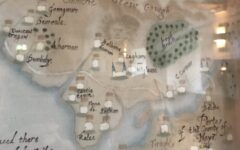
John Speed’s The Province of Connaught with the Citie of Galwaye Described was the first detailed English atlas map of the west of Ireland, engraved by Jodocus Hondius for Speed’s Theatre of the Empire of Great Britaine, published in London in 1611–12. On Speed’s sheet the label O Dondey is engraved along the Sligo coast, inside the belt marked SLEGO COUNTY, between Arras Dondenell — the name by which English scribes knew the Ó Dubhda seat at Ardnarea / Dún Néill — and the coastal settlement of Port Nahaly, with the River Moy (“Moy flu”) running east of the chief’s name.
To anyone reading the map around 1610, the meaning was clear: this is Ó Dubhda country, and this is the chief.
Boazio, 1606
Four years earlier the Italian-English cartographer Baptista Boazio had published his own map of Ireland, incorporated by Joannes Baptista Vrients into the final edition of Abraham Ortelius’s great atlas Theatrum Orbis Terrarum. On Boazio’s sheet O Dondey also appears on the Sligo coast, next to “Arras Dondenell” and within the county labelled Co. Slego.
Boazio’s map is especially valuable to us for a second reason. In the lower-left corner is a small Latin legend, the Expositio Verborum Hibernicorum — an explanation of Irish geographic terms for the continental reader. Its last entry reads:
O — Caput familiae
The prefix O, Boazio tells his reader, denotes the head of the family. The mapmaker is not merely labelling a place: he is declaring that the Ó Dubhda are the ruling family there. Few early European maps state the Gaelic sept-system quite so plainly.
Why “Dondey”?
The short answer is: because that is what English ears heard. In Irish, the chief’s name is Ó Dubhda — the middle consonant cluster bh pronounced not as a hard b, nor quite as an English v or w, but as a soft nasalised glide that has no tidy English equivalent. The final dha drifts, in quick speech, toward a dhe or even dee sound.
A Tudor scribe trying to write the name down in the Roman alphabet did the sensible thing: he wrote it as it sounded. O Doo-dhe. O Dondey. The first n is likely a misreading of a manuscript u — a one-minim slip that has happened a thousand times in old handwriting. What survives on Speed 1610 and Boazio 1606 is a snapshot of our name at the moment it crossed from Irish speech into English print.
Within a century the form would settle toward O’Dowd and O’Dowda as Anglo-Irish scribes smoothed the phonetic rendering into something more regular. But O Dondey remains on the page — a ghost-spelling, a moment of first contact between our sound and their script.
Still on our own ground
By the year 1600 the Ó Dubhda chiefship had already been in continuous existence for more than six centuries, and the English Crown was beginning the long work of surveying, mapping, and ultimately plantation that would dismantle the Gaelic lordships within a generation. These maps catch our family in the last moments of the old order: still on our own ground, still named as the ruling sept, still tied to the River Moy and the inauguration stone at Ardnarea.
A few decades after these maps were engraved, the Ó Dubhda lands would pass into new hands under the Cromwellian settlement, and the name would vanish from the official cartography of Connacht. But on Speed’s 1610 and Boazio’s 1606 — copies of both held today at the Bibliothèque nationale de France, the David Rumsey Map Collection at Stanford, and the British Library — we are still there, on the coast, above the Moy, where we had been since the ninth century.
O Dondey.
Sources
- John Speed, The Province of Connaught with the Citie of Galwaye Described, 1610. Engraved by Jodocus Hondius. From Speed’s Theatre of the Empire of Great Britaine, 1611–12. Scan: Bibliothèque nationale de France (btv1b53057005d), via Wikimedia Commons. Public domain.
- Baptista Boazio, Irlandiae Accurata Descriptio, 1606. Published by Joannes Baptista Vrients in Abraham Ortelius, Theatrum Orbis Terrarum. Scan: David Rumsey Map Collection, David Rumsey Map Center, Stanford Libraries. CC BY-NC-SA 3.0.
See the full cartographic record for the Ó Dubhda family on our Maps catalogue.