
Carn Inghine Briain — Coggins Hill
May 2, 2026 2026-10-14 22:22Carn Inghine Briain — Coggins Hill
CARN INGHINE BRIAIN
Carn Inghine Briain
Coggins’ Hill, Kilrusheighter — the eastern inauguration mound of the Ó Dubhda of Tír Fiachrach
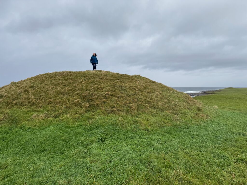
On the Aughris headland in north Co. Sligo, a two-tiered mound rises from a field of pasture above the Atlantic. Known locally as Coggins’ Hill, and in the medieval Irish record as Carn Inghine Briain — “the cairn of Brian’s daughter” — it is the best candidate for the inauguration site used by the Ó Dubhda of Tír Fiachrach on the eastern side of the River Moy, across from Carn Amhalghaidh in Mayo.
A 2025 site visit with Dr Marion Dowd, MIAI, FSA — Lecturer in Archaeology at Atlantic Technological University, Sligo, and a specialist in Irish cave archaeology and sacred places in the landscape — confirmed that the mound on Coggins’ Hill is almost certainly the remains of a castle, and quite possibly of an associated medieval settlement or small town, at GPS 54.264708, -8.787518 ‐ the point identified on the ground by the current landowner. What is visible today has never been excavated; it lies beneath pasture on private farmland in the townland of Kilrusheighter, and is, in Dr Dowd’s phrase, “a found castle — it just needs to be dug.”
I. The “Invented Tradition” of an Eastern Ó Dubhda Mound
The scholarly case for Coggins’ Hill was made most fully by the archaeologist Elizabeth FitzPatrick in Royal Inauguration in Gaelic Ireland, c.1100–1600: A Cultural Landscape Study (Four Courts, 2004). She argues that after the Ó Dubhda reconquest of Tír Fiachrach in 1371, the family began to re-imagine its inauguration landscape on both sides of the Moy — so that the old western mound at Carn Amhalghaidh was paired with a new, eastern mound of equal ceremonial weight. This is what FitzPatrick calls an “invention of tradition”: not a fabrication in the modern sense, but a deliberate re-reading of the landscape to match a renewed political reality.
The name Carn Inghine Briain survives in a single medieval text, and that text does not say where the mound stood. It occurs in the inauguration tract added to the Book of Lecan ‐ the great manuscript compiled by the Mac Firbhisigh scholars in the early 15th century, in the time of Tadhg Riabhach Ó Dubhda ‐ which allows a chief who happens to be at Carn Inghine Briain to take his title there rather than cross the Moy. No dindshenchas or other lore of the place is known, and it is this silence that underpins FitzPatrick’s argument. Who ‘Brian’s daughter’ was is not recorded. John O’Donovan (1844) guessed that she was Meadhbh, daughter of Brian son of Eochaidh Muighmheadhoin, and that the carn was Miosgan Meidhbhe on Knocknarea itself ‐ though he conceded that Knocknarea lay outside the Ó Dubhda’s lawful territory.
II. The Shape of the Mound — an Echo of Knocknarea
What makes Coggins’ Hill the strongest candidate for Carn Inghine Briain is the form of the mound. It rises in two distinct tiers: a broader lower platform, and a smaller capping tier on its summit. This profile ‐ a stepped mound on a natural rise ‐ may be a deliberate echo of Meadhbh’s Cairn on Knocknarea, across the bay to the east, which was by far the most famous ceremonial cairn in the wider region. FitzPatrick reads this as intentional: an inauguration mound for Tír Fiachrach that spoke, in its very silhouette, to the prestige of the Connacht heartland.
The seaward view reinforces the point. From the summit of Coggins’ Hill one looks north to Aughris Head and the open Atlantic, east toward Knocknarea itself, and inland toward the Ox Mountains — a horizon that binds sea, cairn, and kingdom together. For a ruling kindred whose identity was rooted in control of the coastline from the Moy to the Ox, it is hard to imagine a site more eloquent.
III. Archaeology on the Ground
The mound sits in a working cattle field on the townland of Kilrusheighter, a short walk inland from the Aughris cliff-path. To the unfamiliar eye it reads as a rise in the pasture. To the trained eye, as Dr Dowd pointed out on the 2025 walkover, the ground tells a different story: worked stone breaking through the surface, a platform edge that does not belong to natural topography, and the broader footprint of what she believes was a castle — and possibly more than a castle. The precise location ‐ 54.264708° N, 8.787518° W ‐ was identified on the ground by the current landowner, whose family have worked this field for generations.
“There is a very good chance that an entire small town once stood in this field.”
— Dr Marion Dowd, field commentary, Coggins’ Hill walkover, 2025.
Nothing here has yet been subjected to formal excavation. The site is not signposted, is not on the National Monuments Service public-access list, and sits on private farmland. Its scholarly standing rests on FitzPatrick’s landscape reading ‐ the form of the mound, the assembly place-names and Lughnasa gatherings of the headland, and the Ó Dubhda presence in its folklore ‐ and now Dr Dowd’s field observations — an unusually complete combination of evidence for a site that remains visually understated.
IV. The Scurmore Alternative — and the Mermaid’s Children
A rival candidate for Carn Inghine Briain has been proposed at Scurmore, south of Enniscrone on the east bank of the Moy. The Scurmore site is associated with the “Children of the Mermaid” standing stones and the folk-tale of Tadhg Ruadh ó Dubhda and the sea-bride — a tradition linking the ruling line to the Atlantic itself. The tale has strong local currency ‐ Dr Marion Dowd counts some fourteen versions in Irish and English ‐ and the earliest printed record cited by FitzPatrick is W. G. Wood-Martin’s Rude Stone Monuments of Ireland (1888).
FitzPatrick prefers Coggins’ Hill for the two-tiered form of the mound and its echo of Knocknarea, together with the assembly place-names, Lughnasa gatherings and Ó Dubhda folk-memory of the Aughris headland. Whichever mound the Lecan scribe meant, Scurmore remains a place of genuine Ó Dubhda tradition in its own right.
V. The Last Inauguration, and the End of the Tradition
By the later 16th century the political ground under the Ó Dubhda inauguration had shifted. The mound has a place in the clan’s modern story too. When the clan inaugurated its Taoiseach on 9 October 2025, the ceremony was planned for Coggins’ Hill; at the last minute it was moved, and held beside Enniscrone Castle.
The tradition ended formally in 1585. Under the Composition of Connacht ‐ in its County Sligo indenture, the “Indenture of Sligo” ‐ Ó Dubhda of Tír Fiachrach, together with Ó Conchobhair Sligo and the other lords of the county, renounced the right to inaugurate his successor under native custom. The document explicitly names the kindred and the territory, and binds them by formal indenture with the Crown. The old rite outlived the law by a decade: in 1595 Tadhg Buí Ó Dubhda was inaugurated under the protection of Red Hugh O’Donnell, the last chief made under Brehon law. No source places that ceremony at Carn Inghine Briain.
The mound on Coggins’ Hill has never been excavated – a heritage asset waiting for the work that will one day make its story fully visible.
Carn Inghine Briain
Coggins’ Hill — Cairn of Brian’s Daughter
Kilrusheighter townland, Aughris headland, Co. Sligo
GPS 54.264708, -8.787518 · east of the River Moy
Two-tiered mound identified by FitzPatrick as an inauguration site; Dr Marion Dowd reads surface traces in the field as a probable castle and possible small settlement
On FitzPatrick's reading, adopted as an inauguration site after the Ó Dubhda reconquest of Tír Fiachrach in 1371. No individual inauguration on it is recorded.
Unexcavated. Reads today as a two-tier rise in a cattle pasture and is clearly visible on satellite imagery. Surface indications of worked stone and a platform edge; likely castle and possible settlement footprint beneath the sod.
Private farmland — not open to the public. Do not enter without the landowner’s permission.
Eastern inauguration mound of the Ó Dubhda of Tír Fiachrach — the direct counterpart, across the Moy, to Carn Amhalghaidh. FitzPatrick suggests the two-tiered form echoes Meadhbh’s Cairn on Knocknarea.
Confirmed as a probable castle & settlement site during a 2025 walkover with Dr Marion Dowd, MIAI, FSA (ATU Sligo). No formal excavation has yet taken place; the scholarly framing rests on FitzPatrick 2004 and Dr Dowd’s field observations.
Carn Inghine Briain — Coggins’ Hill, Kilrusheighter, Aughris headland, Co. Sligo
Pin at 54.264708° N, 8.787518° W — the two-tiered mound, identified by the landowner, confirmed on site by the Taoiseach with Dr Marion Dowd, and independently tagged as an archaeological site in OpenStreetMap. The mound is unexcavated, unsignposted, and sits on private farmland — please do not enter without the landowner’s permission.
From the Clan
Photographs of Carn Inghine Briain (Coggins' Hill) submitted by clan members.
A Note from the Clan
These pages are researched and written by volunteers of the Ó Dubhda Clan. Our history is vast, and our understanding of it grows with every correction, addition, and story shared by clan members and researchers.
If you have found an error, or have information that would improve this page, please get in touch.