Carrowmably Signal Tower
A Napoleonic coastal tower on Ó Dubhda ancestral ground
The ruin that stands on the hilltop above Carrowmably townland, a few kilometres east of Dromore West on the Sligo coast, is a Napoleonic signal tower — one of the ring of coastal stations built along Ireland’s western and southern shores between 1804 and 1806 against the threat of French invasion. It is not a medieval Ó Dubhda castle; no medieval fabric is recorded on the hill. It stands, however, in the heart of Tír Fhiachrach, the ancestral territory of the Ó Dubhda, and for that reason it is counted here among the allied sites of the clan’s homeland.
I. The townland
The townland name is Ceathrú Mhaible — “Mable’s quarter” — a ceathrú (quarterland) associated with a person named Mable. The Placenames Database of Ireland records John O’Donovan’s 1836 gloss to this effect. Earlier anglicised forms include Carowmabelin (1617 and 1633–6), Carrowmably (1655–7), Carow mabline (1659), and Mullin als. Carromablin (1727). The townland lies in the civil parish of Kilmacshalgan, barony of Tireragh, County Sligo (logainm.ie / 44832).
No medieval castle is recorded on this hill in the principal Ó Dubhda sources. Conor Mac Hale’s 1990 list of twenty Ó Dubhda castles does not include Carrowmably, and neither O’Reilly’s Stories from O’Dowda’s Country (1971) nor its 2018 expanded edition returns a clan stronghold here. O’Donovan’s 1836 Ordnance Survey Name Book does record a “Caislean Cheathramh Mhaible” — castle of Carrowmably — but places it in the neighbouring townland of Carrowrush and describes it as “said to be built in 1790,” a late-eighteenth-century tower rather than a medieval fortification.
II. A Napoleonic coastal chain (1804–1806)
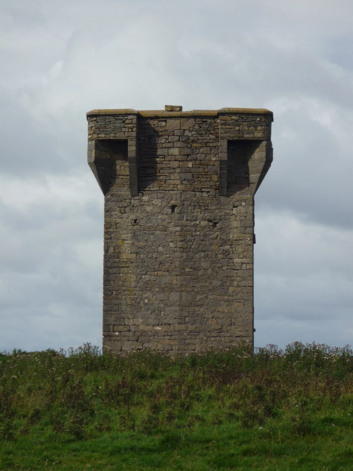
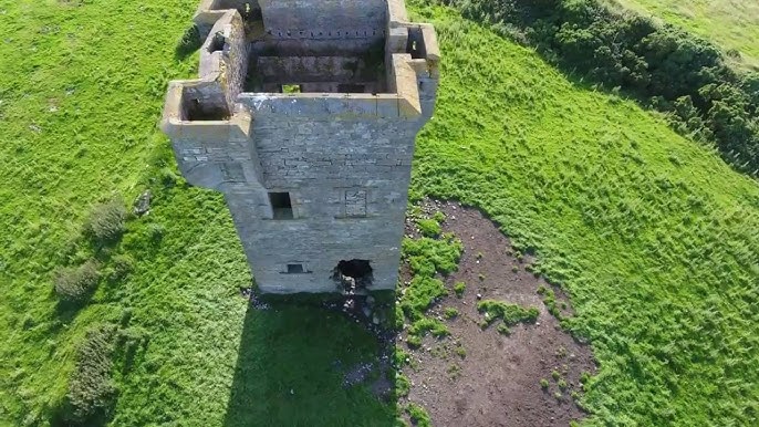
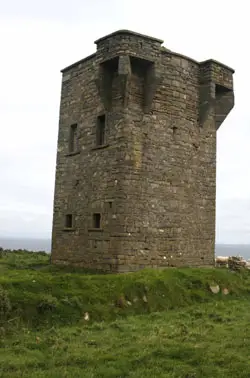
The tower visible today belongs to the ring of some eighty-one signal stations erected along the Irish coast in 1804–1806, after the French landing at Killala in August 1798 exposed how lightly the western seaboard was watched. Each was a self-contained defensible quarter: a square two-storey stone tower with a flat parapeted roof, a raised first-floor entrance reached by a ladder, and corbelled machicolations projecting above the door so that objects could be dropped on anyone attempting to force it.
Crews were small — typically a naval lieutenant, a midshipman, two signalmen, and a detachment of the Irish Sea Fencibles or militia. Messages travelled along the coast by line-of-sight, station to station, using a standard kit of flags, painted canvas balls, and a pivoting upper yard on a tall mast beside the tower. Most stations were stood down from about 1809, when the invasion threat receded; many were later adapted to the Coastguard service or allowed to fall derelict.
III. Carrowmably today
The Carrowmably tower stands largely intact on its coastal hilltop. According to published accounts of the structure, it is one of the better-preserved examples of a Napoleonic signal tower surviving in Connacht. Almost all of the original cut-stone coping remains in place along the parapet; the machicolation protecting the first-floor doorway on the northern wall is nearly complete; the ground-floor fireplace with its flanking alcoves is legible inside, as are the joist holes that once carried the mezzanine and attic. The distinctive bulge on the southern wall housing the chimney flue is still clearly visible.
Less survives of the original weatherproofing — the render or slate cladding that once protected the coastal stone is gone. A ground-floor window on the eastern wall has been opened up in more recent times to allow interior access without the ladder at the first-floor door. The tower sits on private farmland; visitors should obtain the landowner’s permission before approaching. There is no public car park or signage.
IV. The Ó Dubhda connection
Carrowmably lies inside Tír Fhiachrach Muaidhe, the kingdom of the Ó Dubhda from the late Middle Ages until the Tudor reconquest dismantled Gaelic lordship across Connacht. The tower itself was built long after that dispensation had ended: its builders were the British Ordnance, not the clan. We include it on the site not as a clan castle but as a surviving piece of strategic architecture on Ó Dubhda homeland — on the same coastline from which the Ó Dubhda exacted sea-tolls in the high medieval period, and along which the direct Ó Dubhda castles proper (Ardnaglass, Roslee, Enniscrone and the rest) are strung.
The Schools’ Collection (Bailíuchán na Scol, CBÉS vol. 0168, Dromore West, 1937–8) preserves four short anecdotes collected from Carrowmably residents by Miss B. Kivlehan: a local proverb about “sparing it like Bob Devitt and the shoes” (p. 148); a strange story of two women taking clay from a grave in Kilmacshalgan (p. 85); a “strange adventure” told of a man named Gabhadh (p. 95); and a note that Cromwell’s soldiers “never came to this district — he did not pass Beltra” (p. 168). None of these concern the tower itself, and the site has no local folklore of clan feasts or buried treasure recorded in any accessible source.